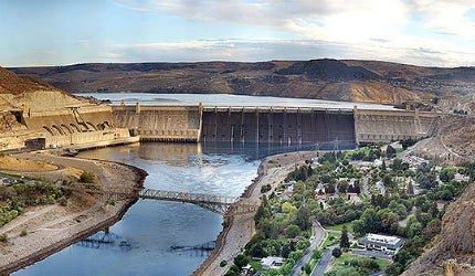
Grand Coulee is a gravity dam on the Columbia River in the US, which serves the purposes of irrigation, flood control and power generation. It forms part of the US Bureau of Reclamation’s Columbia Basin Project which irrigates the central Washington state area.
Construction of the dam began in 1933 and was completed in 1941. The dam was constructed during the Great Depression and played a crucial role during World War II by meeting the power needs of the US and by providing jobs and employment. The project is believed to have created 6,000 jobs during its construction.
The dam’s primary purpose of irrigation was realised only in 1952.
The dam creates a reservoir, named Franklin D. Roosevelt Lake or Lake Roosevelt, which has the capacity to irrigate more than 670,000 acres of land and provides about five million acre feet of space for flood control.
Historical details of the Grand Coulee Dam project
Grand Coulee Dam is the product of a very long process of proposals, planning and debates among various proponents.
The first known proposal to construct a dam to irrigate the Columbia Basin came up in 1892, when a high dam and a canal to divert the flow of water from the Columbia River into Grand Coulee was proposed.
After its formation, the Bureau of Reclamation again brought up the topic of irrigating central Washington.
In 1925, Congress directed the US Army Corps of Engineers to make a detailed study of the Columbia River which later favoured the idea of constructing a dam.
Construction of the dam received support from the then US president Roosevelt due to the dam’s possibility of creating employment during the Great Depression.
Components of the mulitpurpose water scheme
Grand Coulee Dam receives water from Lake Roosevelt. It is pumped using a feeder canal into an equalising reservoir Banks Lake. Banks Lake has been formed by building two earthfill dams on either side of the Grand Coulee. The North Dam at the upper end and the Dry Falls Dam at the outlet.
The main canal begins at the Dry Falls Dam. The water is distributed to various canals from the main canal.
Grand Coulee Dam, along with the North Dam, Dry Falls Dam, Pinto and O’Sullivan Dams and the connecting canals and drains, forms the Columbia Basin Project.
Columbia River dam design
Related project
Delta-Mendota Canal / California Aqueduct Intertie (Intertie), US
Intertie is a pipeline connection between the Delta-Mendota Canal (DMC) and California Aqueduct (CA).
The dam measures 550ft in height and 5,223ft in length. Consisting of 11.97 million cubic yards of concrete, the dam is considered to be one of the largest concrete structures in the world.
More than 12 million barrels of cement, 77 million pounds of reinforcing steel and ten million pounds of steel for the penstocks have been utilised in constructing the dam. A 32-mile railroad facilitated transportation during construction.
Grand Coulee was initially constructed as a low dam due to budgetary constraints. It underwent a design change in 1934 after Roosevelt visited the site and permitted the construction of a high dam, which was eight times bigger than the low dam.
Lake Roosevelt reservoir, formed behind the dam, is 151 miles long, providing a shoreline of 600 miles and an area of 82,300 acres. It has a capacity of storing 9,386,000 acre feet of water and an elevation of 1,290ft above sea level.
As many as 11 drum gates, measuring 135ft long and 20ft high, control the spillway. The spillway has a crest elevation of 1,260ft, a top elevation of 1,288ft and a discharge capacity of one million cubic feet a second.
Water supply from Lake Roosevelt
Water from Lake Roosevelt is pumped using 12 60,000-70,000hp pumps.
Related project
Eastside Reservoir Project (Diamond Valley Lake), California, US
The Eastside Reservoir is built in the saddle of two mountains and located in Riverside County.
The water is lifted at a height of about 280ft, supplying water to Banks Lake at Upper Grand Coulee, through a feeder canal.
The 27-mile lake contains 1.27 million acre-ft of water, of which 715,000 acre-ft is used for irrigation.
Water from Banks Lake is passed on to the main canal, which supplies water to three connecting canals. The canals further supply water to various laterals and from there to various parts of central Washington state for irrigation.
More than 2.5 million acre-ft of water is supplied annually to Banks Lake for irrigation.
Columbia River is fed by glaciers and rainfall. Melting of snow and heavy rainfall at unexpected times causes flooding in the low lying areas, particularly Portland. Lake Roosevelt reservoir helps in regulating the flow of the Columbia River, averting floods.
Key players involved in Washington’s project
The dam was initially constructed by the US Bureau of Reclamation, along with a consortium called MWAK, which comprised of three companies: Mason, Walsh and Atkitson Kier Company.
Six Companies, Inc joined the construction team after the design change for the dam, from low to high. Frank A. Banks, who was the chief construction engineer, led the construction of the dam.
Funds of $66m were provided from federal sources, while $377,000 was provided by the Washington state.
Related content
World’s biggest dam removal and restoration project
Removal of the Elwha and Glines Canyon hydroelectric dams, currently underway in the state of Washington’s Olympic National Park, is not only the world’s largest-ever dam removal, but is also the second largest ecosystem restoration project in the American National Park System.


